Lost town Loyston
Lost Town of Loyston
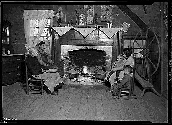
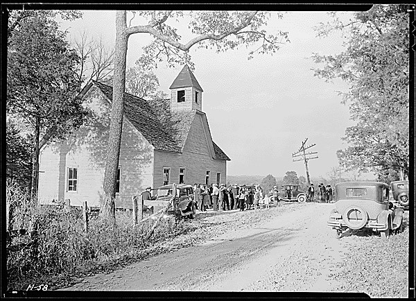
The loss of a family’s history, accumulated over several generations, could not easily be translated into financial compensation when family farms were taken by the TVA to build the Norris Dam. The small town of Loyston, with a population of 70 residents in 1935, was inundated by the waters of the Norris Dam reservoir, requiring the relocation of schools, homes, and even cemeteries.[1] Loyston was about 15 miles from the Norris Dam and is under what residents now call the “Loyston Sea.” This is an inlet of the new Lake Norris created from the Clinch River overflow in 1935. A current-day Tennessee Tourism site describes activities on the water, literally over the old town, as a “popular area for boating, water skiing, and jet skiing.”[2] However, this is not the picture that members of former Loyston families have in their minds when thinking of the lost community.

Today local historians, in some cases family members of those displaced, talk about the emotional stress of being separated from homes where people grew up and from the physical communities where they lived and were emotionally anchored. Sharing a story of one of the older residents displaced from Loyston, John Rice Irwin, founder of the Museum of Appalachia and who was a toddler when his family was displaced from their farm by the TVA, recalls:
"The only thing this lady was saying—she was getting up in years then—and the only thing they [the soon-to-be-displaced residents] wanted, the only thing they asked for was to live out their days in Norris, a very beautiful area. Her grandparents were buried there; some of her babies were buried up on the hill under the cedar trees. She talked about the emotional aspects of leaving more so than the economic aspects."
Another older resident who has served in a variety of civic roles in Norris, TN since the 1990’s attests to the persistent connection between the physical community and the social life of the community:
"All my life, growing up from the time I was a twelve to fifteen-years-old, [we had] …family reunions on Decoration Day,[3] which in the South is typically the fourth Sunday in May. People would come back from all over the country. They would gather at our local cemetery and talk about old times in Loyston before they had been moved out by TVA. And we still maintain that cemetery. And we still have children and grandchildren who return. The South is very land-oriented. When [the] TVA came in and flooded the land, it’s more than just taking the land and displacing the people. It’s basically obliterating the land, with the dam and the waters of the lake. People don’t even recognize that there was a Loyston. (Mariner)"


[1] Julie Graham, “Loyston Sea” Entry on East Tennessee River Valley Geotourism MapGuide. Website. http://www.tennesseerivervalleygeotourism.org/content/loyston-sea/ten83791b0dc6a6bc4ae Accessed February 10, 2016.
[2] Graham.
[3] Decoration Day is the traditional day each year in rural Southern communities when families gather at cemeteries to clean and decorate graves.
[4]National Archives, National Archives Catalog, Records of the Tennessee Valley Authority, 1918-2000. Series: Lewis Hine Photographs for the Tennessee Valley Authority (TVA), 1933-1933. Record Group 142: Records of the Tennessee Valley Authority, 1918–2000. Series: Lewis Hine Photographs for the Tennessee Valley Authority (TVA), 1933–1933. https://research.archives.gov/id/532790 Photograph taken November 23, 1933.
[5] National Archives, National Archives Catalog, Records of the Tennessee Valley Authority, 1918-2000. Series: Lewis Hine Photographs for the Tennessee Valley Authority (TVA), 1933-1933. Record Group 142: Records of the Tennessee Valley Authority, 1918–2000. Series: Lewis Hine Photographs for the Tennessee Valley Authority (TVA), 1933–1933. https://research.archives.gov/id/532681?q=*:* Accessed February 10, 2016. Photo taken October 29, 1933.

